Nelson’s Fortnum Project is located 15 km south-south east of the Fortnum Gold Mine (WestGold Resources) and adjacent to the Labouchere, Nathans and Fortnum group of gold deposits.
These mineralised systems are part of the Proterozoic Bryah Basin which forms the eastern-most part of an extensive Proterozoic Orogen, located between the Archean Yilgarn and Pilbara cratons.
The Bryah Basin is a sedimentary sequence deformed during a number of significant tectonic events during the late-Proterozoic. The latest event, the Capricorn Orogeny, is synchronous with the mineralisation at Labouchere, Nathans and Fortnum.
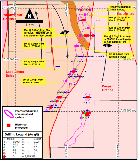
In Nelson’s Fortnum Project, thrust stacking has juxtaposed the Labouchere Formation, the host of the Nathans deposit, between the Archean Yarlarweelor Gniess and the Despair Granite, the host of the Wilthorpe gold deposit.
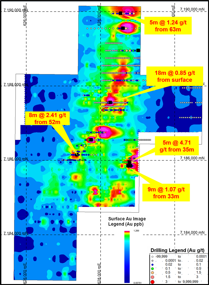
Previous exploration at the project includes surface sampling which identified a number of targets, that were tested by drilling. The drilling returned numerous significant intersections.
Nelson have explored the project since 2017 and have put a substantial amount of effort into compiling the historical data for the project, which includes:
- Aerial photography, aeromagnetic and remote sensing surveys.
- 2,992 surface samples over the area of the project.
- 566 RAB, and some aircore, drill holes for 14,174m.
This work effectively outlined two linear targets coincident with the western edge of the Despair Granite. Further compilation of the geology also identified that significant areas of the project were poorly tested because the original drilling was too shallow or had been
sampled ineffectively.
Out of the 677 assay results returned from the 4m composites sampled from the drilling, nearly 5% were anomalous (i.e.: greater than 0.1 g/t Au). These results are encouraging and give a strong indication of the presence of a mineralised system. However, the drill type (aircore and RAB) are not suitable to allow a JORC Compliant Mineral Resource Estimate to be calculated.
These results will need further exploration drilling in order to advance the project. At this stage, it is anticipated that the future work will comprise aircore drilling to fill in the current drill pattern and define the outline of the mineralised system. Subject to funding, this work will need to be followed up with RC drilling to define mineralisation below the shallower anomalous results identified in RAB and aircore drilling.