The tenements lie within the Edjudina Domain, which is bounded to the west by the Keith-Kilkenny Tectonic Zone (made up of the Yilgangi Fault and the faults bounding the Pig Well Graben) and by the Celia Tectonic Zone (more specifically, the Claypan Fault), which forms the eastern boundary. The domain hosts multiple west-dipping, west-facing homoclinal sequences of mafia to felsic volcanic layers showing lateral facies variation and is cut by low angle faults.
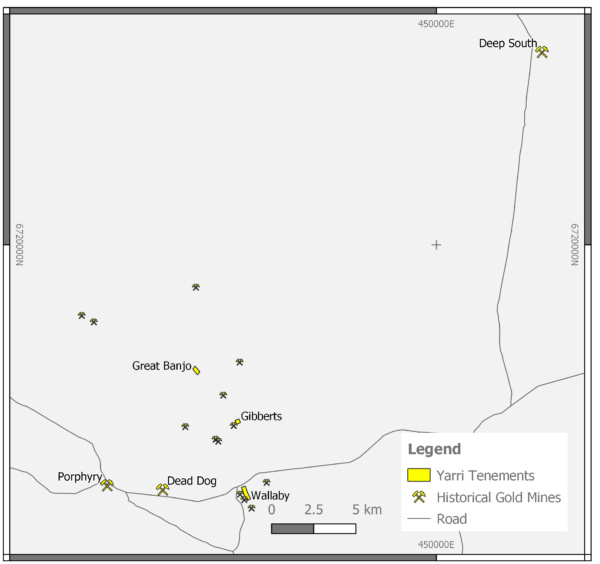
Nelson Yarri project consists of three prospects on three Prospecting Licences to the North and East of the historic Yarri State Battery site.
Historic production occurred in 1902-1914 and 1934-1940. Total production from the Wallaby line is recorded as
21,000 ounces from 42,000 tonnes at an average grade of 15.5g/t Au.
Nelson Resources conducted a maiden 19-hole RC drilling program for 1183 meters at the Wallaby Prospect in January 2018 which delivered high gold intercepts including:
- 1 metre @ 10.8g/t Au from 15 metres
- 2 metres @ 4.87g/t Au from 13 metres
- 5 metres @ 10.67g/t Au from 52 metres
- 1 metre @ 2.17g/t Au from 16 metres
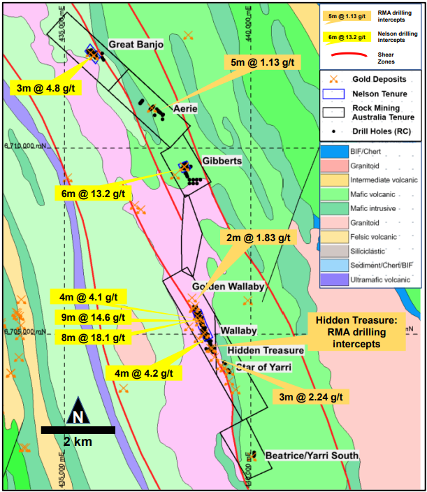
In the period between November 2018 and February 2019 Nelson Resources conducted a 70-hole RC drilling program for 6440 metres at the Wallaby Prospect. In this period an eight-hole RC drilling program for 1709 metres was conducted at the Great Banjo Prospect and a 14-hole RC drilling program for 1248 metres was conducted at the Gibberts Prospect
The Yarri Project is approximately 140km northeast of Kalgoorlie. Historical drilling campaigns at Yarri have generated numerous significant results, as previously reported (Figure 3). Subsequent to the acquisition of the Rock Mining Australia tenure, Nelson compiled all of the drilling data from the project, surveyed all available drill collars with RTKDGPS and then completed rehabilitation on all drill collars. From this work, most of the historical drill collars have been located.
Outside of the Wallaby to Britisher area, the project has been poorly tested. Numerous small and commonly shallow drill programs have tested the prospects to the south but there has been no systematic attempt to define the full extent of the mineralised structure.
The mineralised system, defined by the drilling and historical mining is approximately 1.7km long and stretches from Golden Wallaby to Britisher following the main trend of the Wallaby Shear. Although there are several named prospects along the trend, it is all effectively the same deposit.
Further work is needed at Yarri to realise the potential of the area. Nelson proposes to:
- Complete mapping and sampling on accessible workings to determine controls on
mineralisation. It is well known that the veins are late, have a northerly plunge, parallel
to interpreted regional folding, and are within a high-strain shear zone. However, the
relationship between folds, shear zones and veining are not well understood. - Complete a remote survey of the workings to determine exactly where material has
been removed so that this material can be discounted from resource estimation. - Twin a few holes previously completed by Rock Mining Australia.
- Undertake a regional surface sampling program utilising modern geochemistry to
identify additional mineralisation.


